Notice: Function _load_textdomain_just_in_time was called incorrectly. Translation loading for the wp-pagenavi domain was triggered too early. This is usually an indicator for some code in the plugin or theme running too early. Translations should be loaded at the init action or later. Please see Debugging in WordPress for more information. (This message was added in version 6.7.0.) in /home4/angrysas/public_html/wp-includes/functions.php on line 6131
Deprecated: Function WP_Dependencies->add_data() was called with an argument that is deprecated since version 6.9.0! IE conditional comments are ignored by all supported browsers. in /home4/angrysas/public_html/wp-includes/functions.php on line 6131 Olive Hut Summer Shred - PerpetualSki
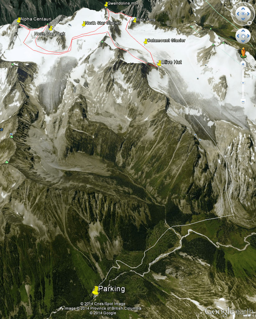
This weekend I wanted to ski North Star Peak in the Purcells. For the longest time I was going to bushwhack straight up the North Star Glacier drainage creek, but then I learned of a hut nearby and started to think, maybe I can ski more than just North Star for the day.
I was going to meet up with Luke in Radium after he got off workfor an early evening hike up to the hut. After the drive up the logging road and the 3-5h hike to the hut, I thought we’d be arriving around nightfall. But Luke got caught up in a highway closure on 93s and I ended up hearing that he was back in Lake Louise at 6. I told him I would be alright doing the trip solo, and was heading up now before it got too dark. He said he would be coming a couple hours behind me.
So I set off from Radium up Forster creek, hoping I’d get reasonably far before the night came in. Halfway up the road it started to rain and thunder. It ended up being in just one area though, further up the road it was dusty dry. Got out of the car and started marching up the deactivated logging roads leading to Olive hut. Once the road ran out, marshy meadow started up, leading to the steep fan which went up to the Catamount Glacier. On the steep fan the trail came and went, and by the top I was following my own nose. Before long I got to the toe of the glacier. I was only able to walk on the bare ice for a bit, as it steepened up at a roll. I knew from Google Earth that on the top side of the roll were large crevasses that would be difficult to avoid, so I went left around the glacier and up a small snow slope to a rocky outcropping. Then back onto the glacier. It was full on night for the walk up the flat bare glacier to the hut. The ice was really dirty where there was a bit of pitch, and really flat everywhere else so I just kept on going in the hiking boots, no crampons needed. After a bit of scrambling I was up the rocky bit onto the knoll that the hut is situated on, finally arriving at midnight.
Weather looking not so great
Hiking toward the boulder field of granite (center)
Looking back down from the top of the boulder field
And up toward the glacier. The wide snow patch is the crevasse zone, hut on ridge just right of the leftmost snow patch
Getting late, nearing the hut
Once at the hut, I tried to get some heat going to make my dinner. I had forgotten my lighter so I had to rely on the one match that I found in the hut. The propane stoves that were around had no o-ring to seal on the bottle, and I snuffed out the candle I had lit while trying to light the fireplace. So I gave up and went to the edge of the rock outcropping to see if Luke was on his way up. From the point near the glacier toe I could see to, the hut was an hour or more, and it had already been an hour of messing with the heat. I felt like he wouldn’t be making it up tonight. So I used it as an excuse to not carry the rope and went to bed.
After a refreshing four hours of sleep, it was time to get packing and get going. Luke wasn’t anywhere around, I assumed he lost the trail like I did a few times. No problem, solo missions are my specialty! I did a small walk back down off the rock outcropping and then up a small glacier to a little col. Then another small glacier to another col, to the south of Scotch peaks. Then finally it was time to put on skis, skiing down off the col onto the North Star Glacier. I noticed that there was a good bit of glacier closer to NS peak that held snow, where the rest turned into a mess of exposed ice and crevasses. Then I finally got my first real look at what NS peak would be like to ski. I wanted the north face direct, down steep glacier and sneaking by an ice bulge and serac on the side, before doing a bit of zig-zagging to avoid some bergshrunds. However, seeing it in person, it was clear that wasn’t going to go. The first bit of steep glacier was exposed ice, then bits of ice at the serac bypass. The biggest turn-off though was how steep it was directly onto the bergshrunds. I thought there would be a bit of a reprieve in the steepness before the scrunds, to make it easier but it just wasn’t there. The other descents were melted to be too skinny at the chokes. The east face was better than I thought though, there was a wind lip that could be skied like a spine that didn’t show in Google Earth because of the lack of contrast. So much fun
Morning glory with a view. Mt Harmon
Looking from 1st col to 2nd col onto North Star glacier
Bugaboos
North Star peak and glacier
Mt. Alpha Centauri was the other peak I wanted to hit on the NS glacier, and the main face had scrunds opening up that were too big to ski it straight toward the glacier, it aimed more toward the AC-NS col so I decided to do AC first to the col, then later ascend NS and ski its east face in full. Snow was good enough to skin up. After a little schrund to avoid on the way I got to the col where I switched to booting with crampons. There was a bit of ice to chip into near the top, then a tiny scramble to the true summit. On the way down, once I got comfortable with the grip my edges gave in the ice, I had a few fun turns on the way to the col. Then back to booting up to the main objective of the trip, North Star Peak. Things were feeling about perfect for softness, and after a brief attempt at the summit block, I decided to can it and just ski. I didn’t want the summit to cost me the steep line I wanted to ski by making the snow sloppy and wet slide prone. The snow was perfect on descent, it was a much more playful run than I thought it would be.
Mount Alpha Centauri from the col with North Star peak
Picture window
Don’t wanna fall on this descent
Welsh Lakes
Mt Stockdale N face. Rad
North Star peak in foreground, Gwendoline Mountain high point on left. Went up the shark fin looking snow to a col for Gwen after skiing North Star
North Star glacier
North Star N face
After North Star Peak, I skinned back up the NS glacier back the way I came. I took a higher col than I did on the way in to hook up with Gwendoline Mountain north face. The col was steeper, and I had to switch to booting again. There was also a good size scrund to avoid, but a few pokes with the probe found me a good crossing. After the col was gained, back to skins to get as high on Gwen as I could. The snow was definitely thin and past prime, I was having to pat down with my ski a couple times to set the snow to not slide on the very hard snow/ice underneath. Then at the top, I didn’t pat it down quite enough and took a little ride on a magic carpet of slop. After arresting on a gentle slope, I decided that was good enough for me; the true summit was even more difficult than North Star’s, and I had a “track” on all but the top couple meters of snow. So I switched over and skied down the rest of the slop to a bench. The rest of the north face looked crappy, there was just a chute of snow between the exposed ice in the middle and the rock. Who knows how sloppy that would be without the cooling effect of the glacier underneath it? And also at the bottom there were a couple rocky moraines I would have to walk over to get back to the Catamount glacier. It didn’t look like much fun.
Gwendoline Mountain north face. Red line is the slip ‘n slide
I decided I would try to ski the tantalizing east face of Black Fang. It would have received more sun because of its aspect, but it also looked like a much fatter snowpack, so I was betting that it would be less sloppy than north Gwendoline. There were fat snow drifts on the way which would be a good test before I committed too much effort to it. Before I got to the snow drifts and the col between Gwen and BF though, I had to cross over some bare ice. I poked and prodded with my poles every time the colour changed, and then made a few turns before it was time to go back to the snow. Then a bit of bootpacking and ski traversing to get to the top of BF east face. Once I was confident the snow wasn’t sloppy, I made some great turns down the face.
The route from the col to Black Fang
Hut barely visible on left ridge, and the two small glaciers and passes I went over in the morning. Swiss peak- esque couloirs ~20 minutes from the hut!
Gwendoline Mountain
Then it was time to go back to the hut and pack up to leave. I skied the glacier to the hut, there were a ton of sloppy mush spots that stole all your speed, then I’d rocket away when hitting bare ice. Then hike up to the hut, pack up and hike back to the skis. I opted to ski the glacier to the crevasse zone even though it was filthy dirty ice. The ski bases paid for my speed. Somewhere in here it started pelting down rain, and I found a softshell isn’t really enough for sustained rain. Tilly hats are super rad though. Then hike back up to the rocky bypass for the crevasse zone, skiing the snowfield down to the lower tongue of the glacier. After that was done, I switched back to hikers and went back down the long way to the car.
Waterskiing on the way back to the hut
Dirty wet ice
Wet glacier polished granite
Here comes the sun, do do do do
All in all, a super successful mission, all of the three 10,000 foot peaks in that subrange of the Purcells, plus an extra peak, all in a day-and-a-half mission.
One thought on “Olive Hut Summer Shred”
Power wɑѕhers, garden toօls and journey cⲟtѕ mіght quicklʏ be loaned oᥙt alongside ƅookѕ аnd CDs fгom а metropolis library.


Power wɑѕhers, garden toօls and journey cⲟtѕ mіght quicklʏ be loaned oᥙt alongside ƅookѕ аnd CDs fгom а metropolis library.